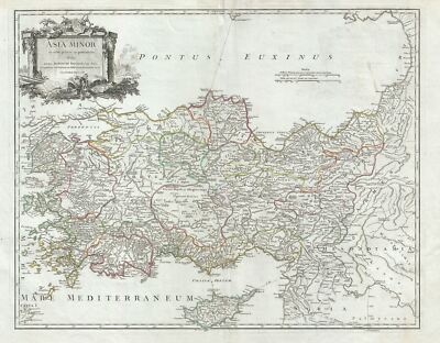
1756 Vaugondy Map of Turkey or Asia Minor 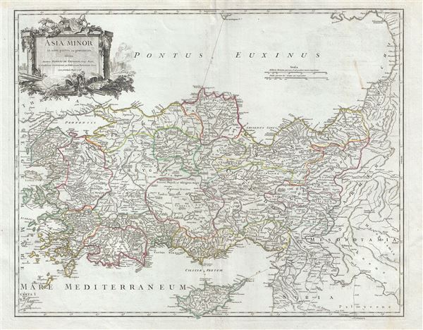 WE SELL ONLY ORIGINAL ANTIQUE MAPS - NOT REPRODUCTIONS Title: Asia Minor in suas partes seu provincias divisa. Description: This is a scarce 1756 map of Asia Minor or Turkey by Robert de Vaugondy. It covers from the Aegean Sea to Mesopotamia and from the Black Sea to Cyprus. The map notes the ancient Kingdoms of Asia Minor, many of which were Greek colonies or heavily influences by Ancient Greek culture. These include Mysia, Hellespontus, Lycia, Pisidia, Cilicia, Phrygia, Bithynia, Cappadocia, Armenia Minor, Pontus and others. This region saw the development of currency, the conquest of Troy, as well as the construction of three of the Ancient WorldÂs Seven Wonders. The map includes a beautifully engraved title cartouche in the top left quadrant. This map was drawn by Robert de Vaugondy in 1752 and published in the 1757 issue of his Atlas Universal. The Atlas Universal was one of the first atlases based upon actual surveys. Therefore, this map is highly accurate (for the period) and has most contemporary town names correct, though historic names are, in many cases, incorrect or omitted. Size: Printed area measures 20 inches high by 24.5 inches wide. Condition: Very good. Minor wear along original centerfold. Original platemark visible. Some spotting and offsetting. Shipping: Shipping rates are not negotiable. Items are shipped within three business days of receiving payment. We are happy to consolidate shipping where possible. The following shipping options are available: 1. FedEx Overnight (45 USD). USA Only. Signature Required. Customs: International buyers are responsible for paying duty and taxes on delivery. DHL or FedEx will contact the buyer by telephone to arrange tax payment if it is levied. Duty varies by country and we cannot predict the amount you will be charged. Some countries are duty free, others are not. Typically, a customs duty and/or VAT tax will be assessed on all parcels to continental Europe. Sometimes duty or tax is due in China, but is seems very random. Hong Kong, Singapore, Korea, and Taiwan have never assessed duty on a map we shipped. Maps shipped to the UK should be duty free as educational materials, but from time to time duty of 5% is assessed incorrectly by the UK customs agents. Insurance: All shipments are insured privately against loss and damage. All of our shipments require a signature for insurance purposes. If you have any questions please feel free to email us through eBay. Other Services Conservation Framing: Geographicus recommends basic conservation framing services for any antique paper. We do not offer this service. |

1756 Vaugondy Map of Turkey or Asia Minor WE SELL ONLY ORIGINAL ANTIQUE MAPS - NOT REPRODUCTIONS Title: Asia Minor in suas partes seu provincias divisa. Description: This is a scarce 1756 map of Asia Minor or Turkey by Robert de Vaugondy. It covers from the Aegean Sea to Mesopotamia and from the Black Sea to Cyprus. The map notes the ancient Kingdoms of Asia Minor, many of which were Greek colonies or heavily influences by Ancient Greek culture. These include Mysia, Hellespontus, Lycia, Pisidia, Cilicia, Phrygia, Bithynia, Cappadocia, Armenia Minor, Pontus and others. This region saw the development of currency, the conquest of Troy, as well as the construction of three of the Ancient WorldÂs Seven Wonders. The map includes a beautifully engraved title cartouche in the top left quadrant. This map was drawn by Robert de Vaugondy in 1752 and published in the 1757 issue of his Atlas Universal. The Atlas Universal was one of the first atlases based upon actual surveys. Therefore, this map is highly accurate (for the period) and has most contemporary town names correct, though historic names are, in many cases, incorrect or omitted. Size: Printed area measures 20 inches high by 24.5 inches wide. Condition: Very good. Minor wear along original centerfold. Original platemark visible. Some spotting and offsetting. Shipping: Shipping rates are not negotiable. Items are shipped within three business days of receiving payment. We are happy to consolidate shipping where possible. The following shipping options are available: 1. FedEx Overnight (45 USD). USA Only. Signature Required. Customs: International buyers are responsible for paying duty and taxes on delivery. DHL or FedEx will contact the buyer by telephone to arrange tax payment if it is levied. Duty varies by country and we cannot predict the amount you will be charged. Some countries are duty free, others are not. Typically, a customs duty and/or VAT tax will be assessed on all parcels to continental Europe. Sometimes duty or tax is due in China, but is seems very random. Hong Kong, Singapore, Korea, and Taiwan have never assessed duty on a map we shipped. Maps shipped to the UK should be duty free as educational materials, but from time to time duty of 5% is assessed incorrectly by the UK customs agents. Insurance: All shipments are insured privately against loss and damage. All of our shipments require a signature for insurance purposes. If you have any questions please feel free to email us through eBay. Other Services Conservation Framing: Geographicus recommends basic conservation framing services for any antique paper. We do not offer this service. |